30+ Traffic
Sources
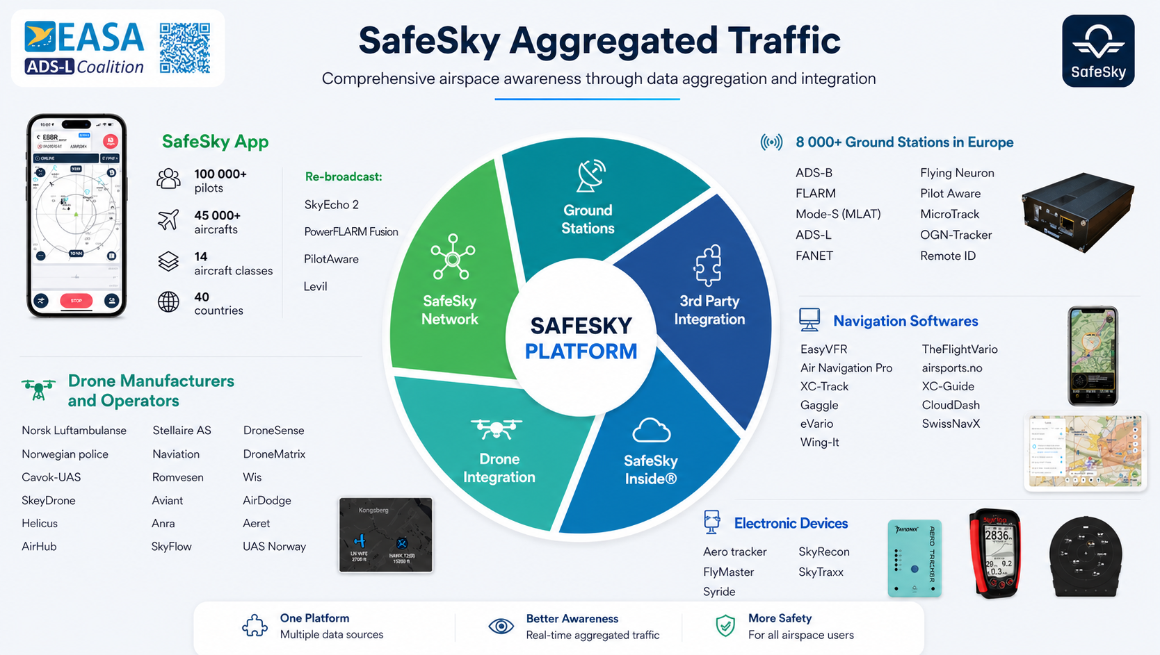
SafeSky aggregates airspace data from the most comprehensive network of traffic sources available, creating a unified air picture with unparalleled coverage and detection capabilities in lower airspace.
How SafeSky Aggregates Traffic
Five independent layers of positional data, each capturing a different slice of the airspace. No single technology sees every aircraft type, so the layers are designed to be complementary, not redundant.
Mobile Application Layer
The SafeSky app is a unique source of cooperative traffic for VFR flights. Pilots share their GPS-derived position within the shared network and receive nearby traffic in return, providing situational awareness across 14 aircraft categories that traditional radio-based systems often miss.
Cooperative Ground Station Layer
SafeSky aggregates traffic received through a crowd-sourced network of more than 16,000 ground stations that passively collect cooperative radio signals broadcast by aircraft. Operators, enthusiasts, and aviation communities worldwide contribute receivers, building dense coverage across multiple protocols.
Professional Ground Station Layer
SafeSky works with specialist ground station providers to extend network coverage in areas where crowd-sourced receivers are sparse. Partners such as Dronetag, Invale, and professional avionics solution providers deploy purpose-built receivers that integrate directly with the SafeSky network, ensuring consistent low-altitude signal reception in critical operational corridors.
Third-Party Integration Layer
SafeSky integrates traffic data from a broad range of external hardware platforms, navigation software systems, and drone operator platforms through direct API integration, expanding coverage to sources that do not broadcast cooperatively via radio.

Collaborative Drone Layer
SafeSky integrates live telemetry from professional drone operators and U-space Service Providers (USSPs) through direct API connectivity. This includes authorised drone flights that may not broadcast via traditional cooperative technologies, improving visibility of drone activity and interoperability between vendors and operators.
By combining these five complementary layers, SafeSky delivers the most comprehensive live traffic information service available for lower airspace.
Complete Traffic Source Portfolio
Explore all the traffic sources that power SafeSky's comprehensive low-altitude traffic picture
SafeSky Network
SafeSky's mobile application, available on both iOS and Android platforms, serves as the core component of this network. The app facilitates real-time position sharing amongst pilots and other users, leveraging GSM connectivity to provide a seamless traffic awareness solution for general aviation.
Technologies & Partners
eConspicuous Hardware
Hardware devices designed to enhance electronic conspicuity by receiving an aircraft's position. When connected to the SafeSky mobile app, the traffic data captured by these receivers is then rebroadcasted to the SafeSky network. Pilots using this hardware effectively operate as flying ground stations, contributing to real-time traffic awareness.
Technologies & Partners
Crowd-Sourced Ground Stations
SafeSky aggregates data from a network of ground stations, providing a comprehensive picture of airborne traffic. This includes inputs from multiple protocols enhanced with multi-lateration techniques for improved accuracy and coverage, particularly in lower altitudes.
Technologies & Partners
Avionics Aero-Network
Professional, managed ground station solution offering more than crowd-sourced options. These stations receive all the same protocols as crowd-sourced stations, with the added capability of supporting RemoteID for drones, enabling more comprehensive and reliable traffic information.
Technologies & Partners
SafeSky Inside Compatible Products
Onboard products with native SafeSky integration that automatically share position information with the SafeSky network and receive aggregated traffic data without relying on the mobile app.
Technologies & Partners
General Aviation Navigation Software
Software platforms widely used by general aviation pilots for flight planning and in-flight navigation. These are natively integrated with the SafeSky network, eliminating the need for pilots to run multiple apps while sharing position and monitoring nearby traffic.
Technologies & Partners

Free Flight Apps
Applications designed specifically for paragliding, hang-gliding, and other forms of free flight. These apps contribute position data from a variety of users with native SafeSky integration.
Technologies & Partners
Portable Handheld Hardware
Portable devices often used by pilots and free-flight enthusiasts for navigation. These devices broadcast position information to the SafeSky network via native integration.
Technologies & Partners
U-Space Service Providers (USSP)
SafeSky supports bi-directional traffic exchange with U-space Service Providers, enabling sharing of cooperative traffic between U-space ecosystems and SafeSky users.
Technologies & Partners
Glass Cockpit Systems
General aviation glass cockpit avionics with native SafeSky integration, enabling traffic exchange directly from onboard displays.
Technologies & Partners
Drone Platform Integration
Integrations enabling drone operators to share real-time telemetry directly from their operational platforms (C2C link), including flights that do not broadcast via traditional electronic conspicuity technologies.
Technologies & Partners
Professional Drone Operators
Traffic data from a growing number of professional drone operators, allowing operational drone traffic to be visible within the SafeSky traffic picture.
Technologies & Partners

Helicopter Fleets
SafeSky exchanges traffic data with several helicopter fleet operators, improving situational awareness for airborne crews and supporting coordination between crewed aircraft and drones.
Technologies & Partners
Competition Networks
Platforms focused on competitive air sports, providing valuable sources of traffic information for lower airspace awareness.
Technologies & Partners
SafeSky Aggregated Traffic
All sources combined into a single unified traffic picture
SafeSky Traffic Data is Trusted By
Leading aviation authorities, operators, and service providers rely on SafeSky's comprehensive traffic picture

Ready to Build with SafeSky?
Explore how SafeSky's comprehensive traffic sources can strengthen your operations and compliance documentation.