
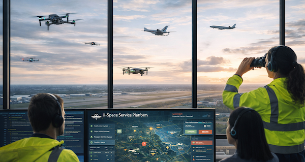
Real-time traffic awareness for Air Traffic Services and Drone Operators
Powering safer, scalable and compliant BVLOS missions. See helicopters, aircraft, ultralights, drones and other traffic in real-time, right inside your mission control platform.
30 days free on any plan. Credit card required, nothing charged until day 31. Cancel any time.
Trusted by Professional Operators Worldwide
Airliners
General Aviation
Helicopters
Ultra-lights
Others


See and Be Seen.
Integrated with Your Operational Platform.
Get instant access to traffic from paragliders, ultralights, helicopters, general aviation, gliders that standard surveillance systems cannot detect.
This unique network now powers your drone operations.
Who is SafeSky For?
Your path to safer drone operations with comprehensive traffic awareness

Drone Operators
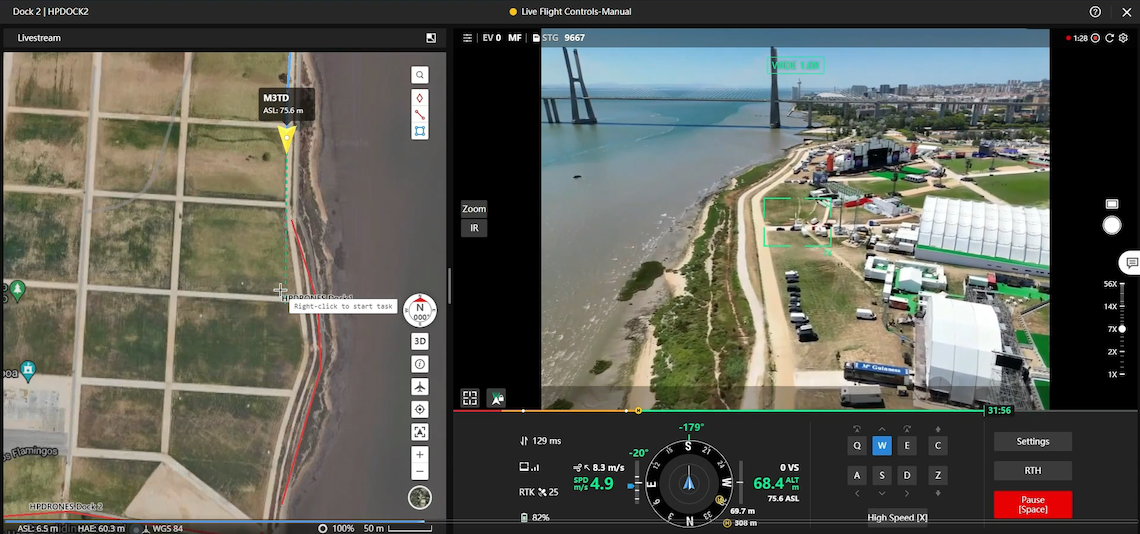
Integrate real-time manned aviation traffic into DJI FlightHub 2, or any other compatible mission control platform.
- 1Create your account and start your free 30-day trial
- 2Copy your API key into DJI FlightHub 2 or your platform
- 3See live traffic and be seen immediately
Trusted by professional operators worldwide
Air Traffic Services
Enterprise-grade real-time traffic data for ANSPs, USSPs and airspace management organisations.
- Best Traffic Coverage
- SORA Ready
- Scalable Infrastructure
Regulatory-compliant & audit-ready

Integrators
For developers and engineering teams building bespoke solutions via powerful APIs.
- RESTful API with full documentation
- Build custom UIs and workflows
- Perfect for specialized operations
Complete documentation & code examples
Everything You Need for Safer Operations
Designed for professional drone operators who can't compromise on safety.
See
Access low-altitude traffic data that you cannot get anywhere else. Know where drones, helicopters, aircraft, and ultralights are, in real-time.
Be Seen
Pilots flying above you will see your drones on their screens. Two-way visibility means everyone stays safe.
Learn moreSORA Support
Meet EU regulatory requirements with built-in airspace risk assessment support. Stay compliant with evolving regulations.
Learn moreTraffic Alerts
Real-time notifications right in your mission control platform when traffic enters your operational area.
Ground Stations
Enhance coverage in your operational area with ground station deployment options.
Learn moreWorks with the tools you already use
Already using DJI FlightHub 2 or a custom platform? Traffic data integrates directly. No switching between apps, no disruption to your workflow.
Seamless integration with DJI FlightHub 2
Custom API integration for your own platforms
Real-time traffic overlay on your existing interface
See and Be Seen in Shared Airspace
Every flight shares low-altitude airspace with helicopters, military, general aviation, and recreational aircraft. Real-time traffic awareness keeps everyone safe, and meets SORA M2 requirements.


WITHOUT SafeSky
Operating blind
Traffic Detection
❌ No visibility of nearby helicopters, aircraft, or other drones in your airspace
Electronic Conspicuity
❌ Your drone remains invisible to other airspace users
Safety Mitigation
❌ Cannot demonstrate detect & avoid capability
Collision Risk
❌ Operating without situational awareness
Flying blind - failing SORA M2 requirements
WITH SafeSky
Complete awareness
Traffic Detection
✅ Real-time visibility of helicopters, general aviation, ultralights, and other drones
Electronic Conspicuity
✅ Your drone is visible to the entire SafeSky network
Safety Mitigation
✅ Proven detect & avoid capability for authorization
Collision Risk
✅ Complete situational awareness and safe separation
SORA requirements ready for flight authorization
Live Airspace Monitor
Real-time traffic
What You See
Simple flight-hour pricing.
Starting as low as 49 € / month
No additional hardware. No complicated setup. No workflow changes.
Trusted by Professional Operators
Stian W. Helgesen
"The SafeSky platform plays a critical role in helping us maintain safety and compliance while scaling our services."
Flight Operations Manager
Aviant, Norway
Mikael Shamim
"Real-time bi-directional traffic visibility is essential for our medical drone operations. SafeSky enables us to see manned aviation whilst making our emergency flights visible to other pilots, which is critical for safe U-Space integration."
CEO
Helicus, Belgium
Sverre Hogstad
"SafeSky has been on our radar for some time, and it finally offered the solution we were looking for. Thanks to SafeSky's integration into HemsWX and Air Navigation Pro, our drones are now visible in the tools used by emergency helicopters."
Chief Pilot
Trøndelag Region, Norway